Automating Earth Observation
Analytics delivered at scale and on demand
Our Capabilities
-

DATA INFRASTRUCTURE
We have experience and knowledge of all aspects of data architecture including data storage, standards, access, compute requirements, governance, resilience and security.
-

COMPUTER VISION
We specialize in deep learning and artificial neural networks to identify patterns in large datasets, including video and satellite imagery, enabling data-driven insights for informed decision-making.
-

GEOSPATIAL ANALYTICS
We are experts in spatial analytics, data visualization, providing advanced solutions that drive informed decision-making and operational efficiency across diverse industries and applications.
About Us
We use data science to monitor and measure change in the environment at multiple scales and we operationalize the monitoring system to support better decision making.
Solutions for Industry
We have helped dozens of organisations and communities across multiple sectors to achieve positive outcomes.
Key Projects
-
![]()
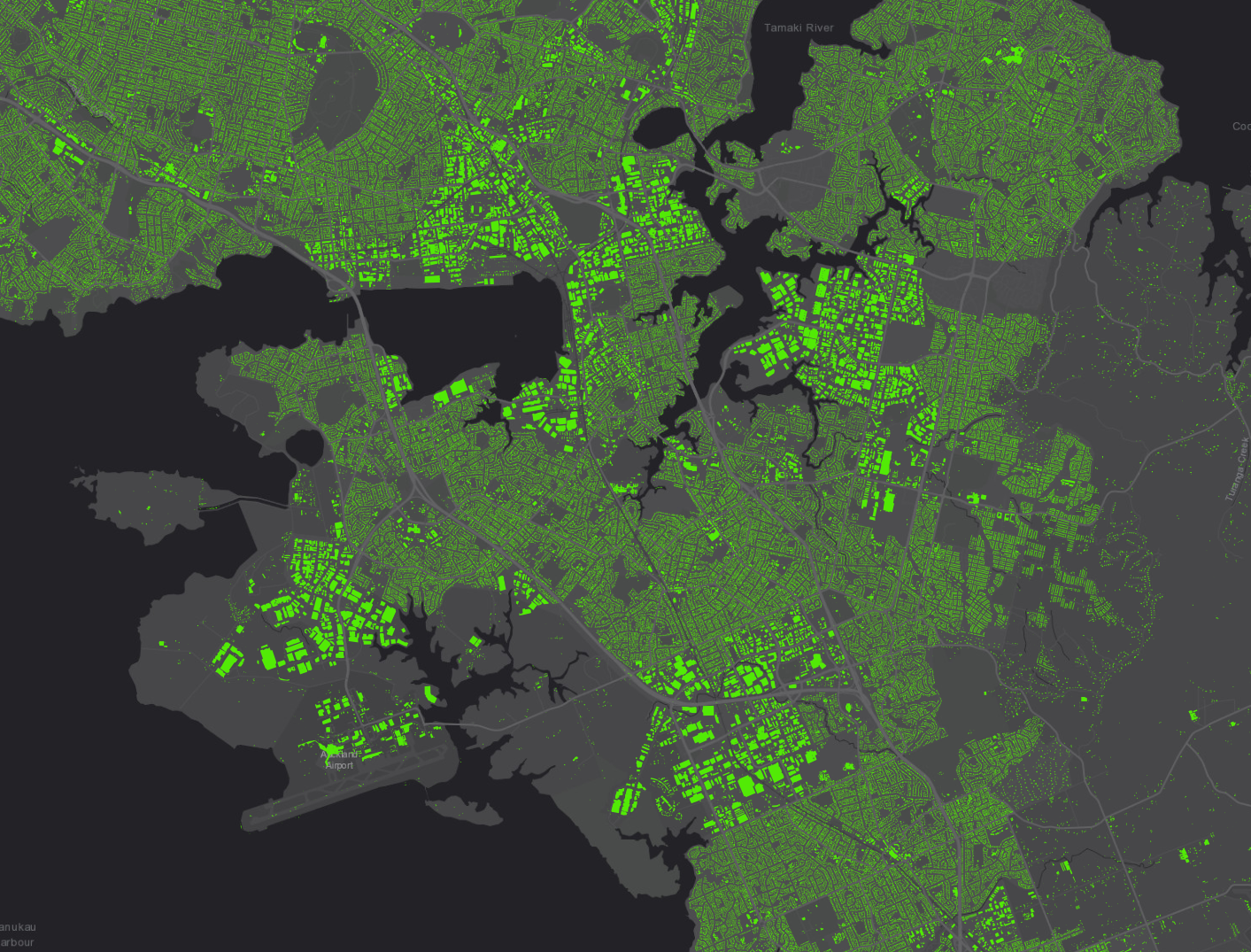
Lynker Analytics completes landmark project to map New Zealand’s buildings
Lynker Analytics Ltd, in partnership with Toitū Te Whenua Land Information New Zealand, has successfully concluded a multi-year initiative to capture building outlines across Aotearoa New Zealand. Spanning over 3 million outlines, the project leveraged AI-driven image analysis to extract accurate 2D representations of buildings larger than 10 square metres from publicly owned aerial imagery.
-
![]()
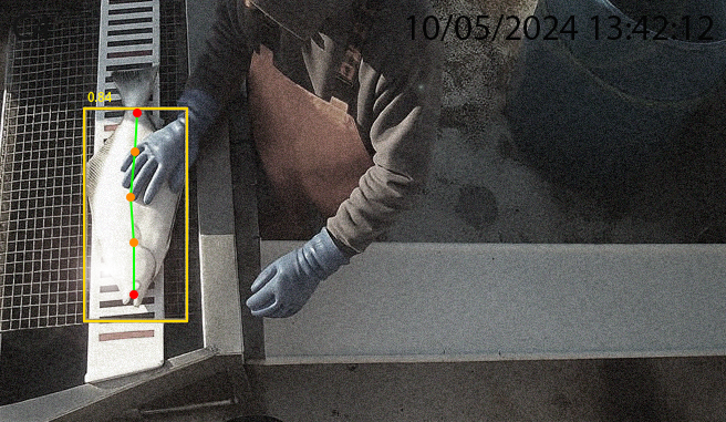
AI-Powered Species Detection and Measurement in the New England Groundfish Fishery
The National Fish and Wildlife Foundation, along with NOAA, Teem.Fish and Lynker Analytics have worked together to produce machine learning models for the purpose of detecting, speciating and length measurement of various groundfish species in the New England fishery. With the core goal being able to more efficiently perform electronic monitoring on fishing vessels to gain greater understanding of the current distributions of species caught and their age brackets.
-
![]()
An AI generated inventory of wetlands and beaver ponds in the Colorado River Basin
As part of their 2025 Environment program strategy, the Walton Family Foundation funded Lynker Technologies, Lynker Analytics and the Colorado Natural Heritage Program(CNHP) to provide a comprehensive inventory of wetlands and beaver activity across the US portion of the Colorado River Basin.
-
![]()
Farm-specific climate risk assessments
In 2023 Pāmu commissioned data science experts Lynker Analytics and New Zealand experts in extreme weather and climate change, Professor David Frame (University of Canterbury) and Dr Luke Harrington (University of Waikato), to help understand vulnerabilities to climate risks such as drought, heavy rainfall and extreme heat across their farms.
-
![]()
Modelling roof condition with deep learning
Christchurch City Council worked with AI provider Lynker Analytics (Lynker) to develop an automated and explainable Machine Learning model to predict roof material and condition across the city.
-
![]()
Impervious area mapping – Christchurch City
In this project Lynker Analytics used modern Machine Learning methods to generate a new detailed impervious area map of Christchurch City including the outlying urban areas covered by the extent of the 2023 Christchurch 0.075m aerial imagery survey.
-
![]()
Monitoring high country transects with Machine Learning
Lynker Analytics was commissioned to develop a convolutional neural network (CNN) semantic segmentation model to automate the classification of each photo into its fractional ground cover to enable scientific interpretation.
-
![]()
Riparian Planting Survival Assessment
As part of the Ministry for the Environment’s Mahi mō te Taiao | Jobs for Nature programme a combined Pattle Delamore Partners/Lynker Analytics team assessed the suitability of different remote sensing methods including satellite, airborne and unmanned aerial systems to monitor these ecosystems.
-
![]()
Virtual eyes on stormwater assets
Developed with Lynker Analytics and Mott MacDonald, the system uses a network of solar-powered cameras installed at 7 sites across the city with each device configured to acquire up to 10 images per day. Images from each site are sent to Moata which is a smart infrastructure monitoring system used by Auckland Council to visualise the performance of water assets enabling optimisation and focused maintenance.
-
![]()
Modernising Auckland’s height data
Toitū Te Whenua Land Information New Zealand (LINZ)is now encouraging local government agencies to migrate their geospatial data to use NZVD2016.
To help prepare for this change Auckland Council contracted Lynker Analytics to provide an assessment of the impact of this transformation to their data and procedures and the programme of work required.
-
![]()
Wetland detection on the Kapiti Coast, NZ
Environmental science and engineering specialist Pattle Delamore Partners(PDP) and data science specialist Lynker Analytics produced the first high-resolution wetland detection map of the Kapiti Coast using Machine Learning (ML), Light Detection and Ranging (LiDAR) and high-resolution Red-Green-Blue-Infrared (RGBI) aerial imagery.
-
![]()
Mapping the impervious surface and land cover in Auckland
In this project Lynker Analytics used Machine Learning to generate a detailed multi-class land cover map across the entire Auckland Council region (approx. 5,000 sq km) covered by the aggregate extent of two aerial photo surveys including the 2010-2012 survey at 0.5m spatial resolution and the 2017 survey at 0.075m spatial resolution.
-
![]()
AI for the Environment in NZ - Report
AI for the Environment in Aotearoa New Zealand - a new report by the AI Forum of New Zealand was released at Techweek in May 2022. This significant report provides an analysis of opportunities and benefits of applying artificial intelligence to support environmental sustainability in Aotearoa New Zealand.
Matt Lythe from Lynker Analytics managed the research team that developed the report which included Antistatic, wildlife.AI and Tahito.
-
![]()
Mapping land cover and land use with AI
in 2021 Lynker Analytics partnered with Bay of Plenty Regional Council Toi Moanato develop an updated and comprehensive land use dataset over the Bay of Plenty. A previous layer had been developed in 2017 using an assembly of data such as Landcover Database(LCDB), AgriBase, Consents data, and aerial photography.
-
![]()
Advancing disaster relief planning with AI
To enhance the update of mapping datasets through collaboration between NZDF and the Pacific Islands, NZDF approached Lynker Analytics to a trial a Machine Learning (ML) approach to automatically extract building and road features from satellite imagery over four Pacific Island territories: Fiji, Samoa, Tonga and the Marshall Islands which could have key benefits for disaster response support or other humanitarian relief requirements
-
![]()
Migrating critical systems to the AWS Cloud
Wellington City Council officials asked Lynker Analytics to migrate their existing Sybase and SQL Server database infrastructure and their ArcGIS GIS technology stack from existing environments to equivalent EC2 servers in the AWS cloud. This was part of a major transformation to re-platform the entire IT infrastructure to AWS in order to reduce IT operational costs and increase infrastructure flexibility. The Lynker Analytics team worked in close partnership with WCC experts, Consegna and AWS.
-
![]()
Mapping metropolitan areas with machine learning
In late 2019 Lynker Analytics was awarded a contract to use machine learning to extract land surface classes from the most recent (2019) high-resolution aerial photography encompassing most of the TCC area (approximately 210 square km). This work was focused on the need to produce detailed land cover maps to inform hydrological imperviousness estimates and hydraulic roughness for overland flow for the city’s 2D stormwater models.
-
![]()
Using AI to identify areas of deforestation and replanting
Lynker Analytics with partners, Carbon Forest Services and UAV Mapping NZ Ltd were contracted by the Ministry for the Environment (the Ministry) in late-2019 to survey and classify around 7,500 distinct areas of potential forest loss across New Zealand.
-
![]()
Rooftop solar value estimation
In a New Zealand first, homes.co.nz has partnered with Lynker Analytics, and New Zealand’s leading solar power provider, Harrisons Energy Solutions, to calculate, calibrate and display the annual retail value of residential solar systems for properties across New Zealand.